
The Grid
By Nicole Sylvia
The versatility of the grid as a structural element for both abstract and physical space is profound. The conceptual figure of the grid has served as the foremost avatar of architecture’s understanding of control and order since antiquity—from the mythology of the temple to the military efficiency of Roman city planning; from the enthusiastic abstraction of the grid by the modernists, to its many nuanced redeployments in the post-modern era.
The grid is wildly malleable, shape-shifting to fill seemingly whatever role is required. In some applications the grid serves as a brazen symbol of unfettered rationality and order, extinguishing any sense of wildness, while in others it is a way of tempering dominant systems of power, making space for diversity to flourish. We inevitably turn to various forms of these ordering grids in our interventions and in the spatial devices we create, whether to provide structure to a process or limit the discrepancy between aspiration and outcome.
The grid provides a platform on which to study and speculate upon the complex relationship between control, order, and wildness; it serves as a proxy or index to trace these conceptions as they evolve throughout time. In order to better understand these relationships—and how the grid may facilitate them—this essay attempts to critically consider the utility of the grid in art against its deployed as a device of colonization across the American West via the Public Land Survey System (PLSS).

IMage 1 / Logics of the Jefferson Grid, 2016. Drawn by the Author
The Grid in Art
The grid is an element that can be easily deployed and understood in both physical and abstract space. Rosalind Krauss’s dissection of the grid and analysis of its role in modern art holds deep parallels within architecture. (1) Krauss details three roles of the grid in art which are useful in understanding how the grid may serve as a proxy for control in regard to built form.
The first extraction from Krauss’s analysis is that the grid is capable of establishing intensely contradictory contexts for a work. This is possible because the grid can mean many different things depending on how it is being situated. The grid may be used to communicate the “antinatural”, the “antireal”, or “illusion”. It may signify “surface” or “space”, “form” or “material.” It may represent “universal” and “fragment,” just as it represents “emblem and myth”. (2) Such flexibility comes from its ability to walk the line between material and metaphor, serving as one or the other or both as readily as needed. With such dexterity, the grid is well situated to accommodate and respond to the simultaneous vagueness, fluidity, and endless resulting possibilities of complex systems; indeterminacy is native to the grid.
In Krauss’s second point, she argues that, in dealing with the entities subjected to it, the grid can act a means by which to neuter autonomy:
Insofar as its order is that of pure relationship, the grid is a way of abrogating the claims of natural objects to have an order particular to themselves; the relationships in the aesthetic field are shown by the grid to be in a world apart and, with respect to natural objects, to be both prior and final. (3)
By its mere existence, the grid implies relations where no operational, formal, or aesthetic relations may necessarily exist. The act of placing an overlying grid checks autonomy and creates new relations.
The third power the grid affords the artist is the ability to construct what Krauss terms an “infrastructure for vision”—which for the architect could be taken to mean an understanding of the grid in relation to its limits. She suggests that there are two main modes of relating the grid of the artwork to the reality of the rest of the world: centripetal and centrifugal. The former implies a drawing in toward a centre, establishing “something complete and internally organized,” bounded by implicit or explicit limits. The latter, on the other hand, speaks to a “theoretical continuity of the work of art with the world”—the extension to infinity so characteristic of Modernist art. Thus, the ordering lines of the grid can be seen to take on deeply contrasting tendencies: in one sense, coming to serve as borders that delineate a finite fragment, while in another sense resembling open trajectories, that seek to extend the logic of the grid outward to an infinity.
The Grid in Space
As a concrete abstraction, the PLSS, or the Jeffersonian Grid as it’s colloquially known, is the defining feature of much of the United States from the air. The Grid has played a complex and contradictory role throughout its 250 years of existence, serving as both a statement of abstract Enlightenment ideals and in playing and instrumental role in the colonization of the Western frontier. Continually shifting in roles throughout its life, the Jefferson Grid serves as a spatial-temporal arena for understanding of the ordering processes deeply ingrained in the American landscape.
Though widespread today, the use of an abstract, geometric grid for the purposes of determining land tenure was a relatively novel approach at the time the PLSS was established (4). Thomas Jefferson (the main initiator of the PLSS and the source of its colloquial name) saw in the cadastral grid the possibility for a dramatic social and spatial transformation of the young nation—addressing in one gesture a host of concerns troubling the government of the time (5) while simultaneously establishing an ideological vision on which to build a democratic and free society (6). In his vision, the simple spatial unit of the grid served as a device to reconcile a host of competing ambitions: taming the frontier, feeding the nation, transforming immigrants into the “yeoman farmer” ideal, and creating what he saw as the ideal conditions for a democratic society.
What preceded the PLSS was the laborious traversing, observing, documenting of the land in question. The order of the plats was derived directly from the landscape based on conditions such as everyone needing to be adjacent to a body of water, or relying on negotiated, distinguishable natural landmarks to which to assign the boundary. West of Appalachia, the provision of landmarks was difficult; there was neither enough time nor resources to dedicate to identifying and documenting (sparse) landmarks. Ideologically, the landmarks were not distributed in a way that could satisfy Jefferson’s democratic vision. The Grid provided a way to map the landscape abstractly, defining it in new terms—terms necessary for the efficient distribution of land.

Concessions of Geometric Purity, 2019. Map data: Google
Grid as Landscape
Geometrically, the cadastral grid is efficient because it requires minimal numbers of turns to get anywhere on it. This enabled eighteenth century urbanites with no experience of farming and no knowledge of the countryside to buy a plot of land in unfamiliar territory hundreds of miles away, yet still be confident that they could navigate there easily. Furthermore, it is infinite in all directions, accommodating however far the West expanded and indifferent to what might constitute the landscape.
In confronting reality, concessions of geometric purity, however, did need to be made. The first concession arises from the curvature of the earth. Without taking this into account, the gridded plots become smaller as they progress north. To accommodate this the eleven northern and western most sections of each township are distorted from the regular square form to match up with the square sections of adjacent townships. Additionally, the grid shifts and resets every 24 miles (39 km)of latitude to prevent the longitudinal limits of the sectors from becoming too small as the grid progresses northward. The second is that people make mistakes, and their imprecisions have disruptive rippling effects on such rigid, clear systems as the Grid. Therefore, several meridians and longitudinal baselines were set, often based on landscape features that would have served as traditional landmarks, to provide a means of resetting the grid, to prevent it from going too awry. The third concession was that while the smallest unit of the grid was derived from the size of land needed for a suitable farmstead that could provide for itself and the growing population—deemed to be 40 acres (.16 km²)—in practice, though each plat contained 40 acres (.16 km²) , there was no guarantee that any of it would be suitable for agriculture. It is in these moments where it is clear that the concept of the grid supersedes its practical utility but is all the more powerful for not yielding to them.
Often, the unknown landscape would be conflated with the blank landscape, conveniently devoid of any content or logics that might resist any new intent applied to them. In this sense, the grid provided a mechanism for taming both the landscape and the many inhabitants that occupied it at the time of subdivision: “erasing” the contents of the landscape and building it back up selectively. Without a recognized history, without monumental architecture, without a landmarked terrain, the landscape was easily rendered conquerable through the promulgation of the ordering of the Grid. The landscape was tamed through a combination of conceptual understanding and physical alteration. This is evidenced in how the widespread elimination of native human, flora, and fauna populations effectively stripped the landscape of any meaning it carried to be supplanted by its conceptualization as an unclaimed bank of exploitable resources.

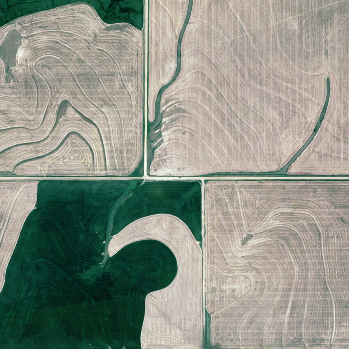
Continuity and Limits, 2018. Map data: Google
Grid as Platform
Taming, however, was not just exercised on the landscape—the grid was seen as a device for taming the incoming population as well. When imagining the survey system Jefferson spoke about the “Yeoman Farmer”: an ideal citizen who had the characteristics and ethic required to support himself and his country. It was his intent to spatially and socially organize the landscape in such a way that would underpin the democratic society he imagined.
The Grid has a powerful characteristic of scalability, on which numerous social units were hung. That is to say that at a given scale, all units are homogeneous, and the units of that scale may be nested into a unit at another scale of homogeneous units; the landscape was able to be divided and distributed evenly in a way that had informative social structures built into it. The smallest unit, a quart-quarter section is defined by the farmer: his family, his house, and his plot of land of 40 acres (.16 km²). Four quarter-quarter units made a quarter unit around which a local road was built for equal access to each farmstead. Four quarter units constituted a mile by mile unit (1.6 km) known as a sector, the limit roads of which were main roads. 36 sectors formed a township. In every township the sixteenth sector was dedicated to the school, and the 29th to religion. This social hierarchy was replicated across Middle America and was thought to be the prerequisite of a democratic society.
Long since shrugging off the Jeffersonian ordering imperatives of its founding, the contemporary state of the PLSS only serves to further illustrate the radical openness of the grid. Criss-crossing it with infrastructural lines and dotting it with settlements, inscribing it with mechanized irrigation and eroding it with land reserves, overlaying it with new forms of property rights and vesting it with a surprising three-dimensional thickness, the contemporary inhabitants of the grid take full advantage of its current passive openness—no longer tethered to the strict social and spatial means of order and control of its inception.
In an architectural context, Rem Koolhaas’s ruminations on the Manhattan Grid in Delirious New York and Superstudio’s Continuous Monument are two of the most iconic uses of Cartesian grids in recent architectural history. Both find in the seemingly-rigid armature of the grid an infrastructure for an agenda of openness—achieving dramatically different effects due to how the grids are conceptualized and deployed.
Koolhaas contextualizes the grid in an ordering of the wildness of the contemporary metropolis, stating that:
The Grid makes the history of architecture and all previous lessons of urbanism irrelevant. It forces Manhattan’s builders to develop a new system of formal values, to invent strategies for the distinction of one block from another. The Grid’s two-dimensional discipline also creates undreamt-of freedom for three-dimensional anarchy. The Grid defines a new balance between control and de-control in which the city can be at the same time ordered and fluid, a metropolis of rigid chaos. (7)
For Koolhaas, the grid is a profoundly and paradoxically generative mechanism of ordering—highly defined in some aspects and absent of definition in others.
Superstudio conceptualizes the grid as a platform—a continuous surface of support, an infinite extension of infrastructure. Redeploying the totalizing desire for infinite extension within modernism and then-emerging consumerist capitalism that so concerned theorists at that time, the Continuous Monument finds within the infinity of the grid a freedom of movement and expression.
The grid leads an odd double-life: both invariably abstract and resolutely real, both ruthlessly rigid and obstinately open, both deeply associated with particular ideologies and oddly a-historical, both a potent device of control and a liberating infrastructure for possibility. It is rigid and unyielding, fixed and ungenerous; it is a generator of diversity and vitality, a platform to support a blossoming of new forms and new ways of life.
Endnotes
(1) Rosalind Krauss. “Grids,” October, Volume 9 (Summer 1979): 50–64
(2) Ibid, 52-63
(3) Ibid., 50–51
(4) Andro Linklater. Measuring America: how an untamed wilderness shaped the United States and fulfilled the promise of democracy.” New York, Walker & Co., 2002): 40
(5) Ibid, 39
(6) Ibid, 52
(7) Rem Koolhaas. “Delirious New York.” (New York, The Montacelli Press, 1994), 20
Bio
Nicole Sylvia is an architectural designer at Patkau Architects and an adjunct professor at the University of British Columbia, as well as a co-founder of Contingent, a multidisciplinary design and research collective.