Touching the Land

By Kat Kovalcik
The North is shifting.
The Canadian Arctic is a site of environmental, social and geographical change. Many indigenous knowledge-holders, politicians and academics have endeavoured to make these changes known, and yet the North appears to persist as a static landscape in the collective consciousness of the South. Through this unchanging lens, the land is still considered a vast and vague “ice desert.” (1)
From the ground, it is clear this place is not an ice desert. Strong warming trends are rapidly reshaping the land and impacting the lives tied to it. (2) The urgency faced by this region has entangled two realities. The first reality is that of the real North: the land that is intertwined with the lives of people who have inhabited it for countless generations. The second is the reality of the newcomers: the scientists and the often distanced architects and engineers who explore these critical issues of environmental change. (3) In this rapidly shifting context, both resonance and dissonance can occur between these co-existing actualities.
My own experience working as an architectural consultant with the Vuntut Gwitchin Government in Old Crow, Yukon, while laying the foundation for a Master of Architecture degree, grounded me amidst these two realities. Here, large shallow lakes and serpentine rivers flow past ancient hills that geologists believe were not enveloped by ice in the last glacial period. This land is the traditional territory of the Van Tat Gwich’in: the people of the lakes, whose roots in the area stretch back millennia. (4)
From afar, I had studied the Porcupine caribou herd’s migration range and Gwich’in culture from the same distanced perspective that I had researched permafrost maps, polar illumination charts and environmental projections. These bearings that I had followed as an architecture student, brimming with inexperience, were of little use in orienting myself on the ground. I wondered if the outside architect could approach any place with open eyes and an open mind. I tried to attune myself to this new frame of reference, knowing that my reading of it could never be deep enough to be considered complete. If the practice of architecture is an act of service, then those who engage in its design cannot work out of habit. Perhaps the architect must first be disoriented before she can appropriately listen to the lessons of the land and the people that live close to it.
The region encompassing Old Crow might be considered a durational environment: a meshwork of forces in constant flux. Despite its location within what scientific experts term a “continuous permafrost zone,” factors such as seasonal freeze-thaw cycles, permafrost degradation, erosion, and flooding are registered as changes by the ground plane. (5) These changes are manifested in eroding river banks, landslides and undulating building pads. Any notion of stasis in this place is challenged by the shifts seen by those who know this land.
Strong and deeply knowledgeable Gwich’in voices are important instigators and collaborators in research within their traditional territory. (6) Local understandings and observations of the land serve as solid foundations for contemporary research practices, approaching a more horizontal relationship between the community’s concerns and the work of southern-based technical “experts”. (7) Across the Canadian Arctic, a similar valuation of place-based knowledge and observations over distanced, technical aptitude is occurring in research on subjects such as climate change, prompting a “reordering of expertise.” (8)
As a student, I wondered how, or even if, the newcomer architect might engage in these reordered discussions of environmental change. As active participants in this durational environment, buildings seem to share in telling these narratives of change. As I searched for some small way to make my own learning potentially useful to those I was learning with, one technical building joint surfaced in multiple open conversations.
The foundation – often considered a banal detail that connects a structure to the ground – is a site of dialogue between the respective movements of the building, people, and the land. At the same time, as a site of mediation, a foundation or groundwork can register changes in the ground plane, and the complex web of relationships in which it is enmeshed. Some foundations shift with the land, requiring varying degrees of re-leveling, while others resist any movement.
As I visited built sites in this territory and met the minds and hands that made them, I became more attuned to the subtle realities of this changing place. I was a stranger here, who came with only an attentiveness and sense of gratitude. And yet, I was invited by friends and elders into their homes and camps. In listening to people and buildings, I began to consider how many of the movements that occurred in the negotiation between a structure and the land could be translated into the realm of everyday experience through foundations. Manifested in the physical experience of a building, these dialogues could be seen in undulating floorboards, heard when buildings hummed in a strong wind, and felt when doors refused to close.
In Old Crow, each approach to building upon this shifting land that I was introduced to presented me with a different portrait of the dynamic human and non-human forces acting upon the ground and building. Perhaps the architectural community would benefit from a re-leveling of who and what prescribes success in the relationship between architecture and the land it is founded upon.
In this part of the North, the land cannot be considered a static landscape. It is a shifting field that moves us through its changes, both transient and durational. In this place, animated by continuous becomings, both human and non-human forces alter the ground. Foundations shifted by environmental factors continue to confound itinerant architects and remotely operating engineers in their efforts to design solutions that define the relationship between buildings and the ground from a distance. In northern Canada, a region where a history of settler colonialism has left its mark on buildings designed by the South, it is imperative that architects engage in meaningful relationships with communities in order to collectively build designs that are of those places. Each can only be considered successful from within its unique context.
Foundations are often defined by regulations developed in the South, reducing their contextual relationships. There appears to be a dissonance between the quiet, everyday imposition of these precepts upon these literal connections between building and ground and the deep cultural ties to the land present in this territory. While the only landscape these regulations are grounded in is the paper they are written on, they define many of the materials that compose these systems such as chemically treated wood from distant forests and locally quarried gravel. (9) The architectural community might benefit from understanding building codes and specifications – which are often understood as having objective technical value – relative to the impact they have on social and environmental relations in the land they will be built upon. (10) The success of architecture in these contexts might be revaluated by local voices – particularly in determining how buildings should touch the ground.
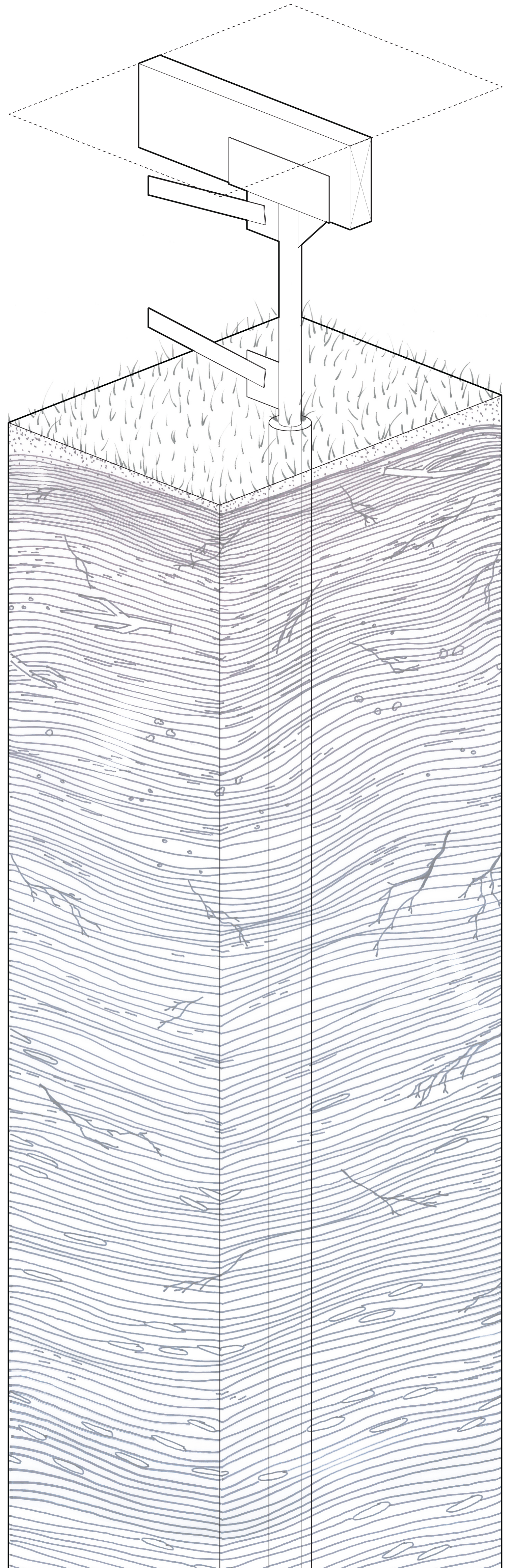
The negotiation between architecture and the land can be navigated through the varying attitudes afforded by different foundation typologies. Deep foundations such as those made from steel piles appear to search for stasis on the ground’s surface by reaching far beneath it, resisting the land’s movement. These deep pile foundations, made from engineered products of distanced material flows, seem to embody a figure-ground relationship with the land. In figure-ground architectural diagrams, a solid black block, or “figure,” is projected against a seemingly unmoving white void, or “ground.” This relationship between built architecture and unbuilt space appears to isolate the building as an object, discounting its inherent connection to the land.
The reciprocal relationship between movements of anthropogenic materials and the ground is embraced by more temporal foundation solutions that adapt to the shifting nature of the earth, seeking an attunement to it. While a building presses down on the earth, the ground plane might simultaneously assert its agency by exerting its own force on a building through the foundation. In this dynamic relationship between building and land, each is transformed by the presence of the other. In short, there exists a delineable “figure-figure” relationship between the two.
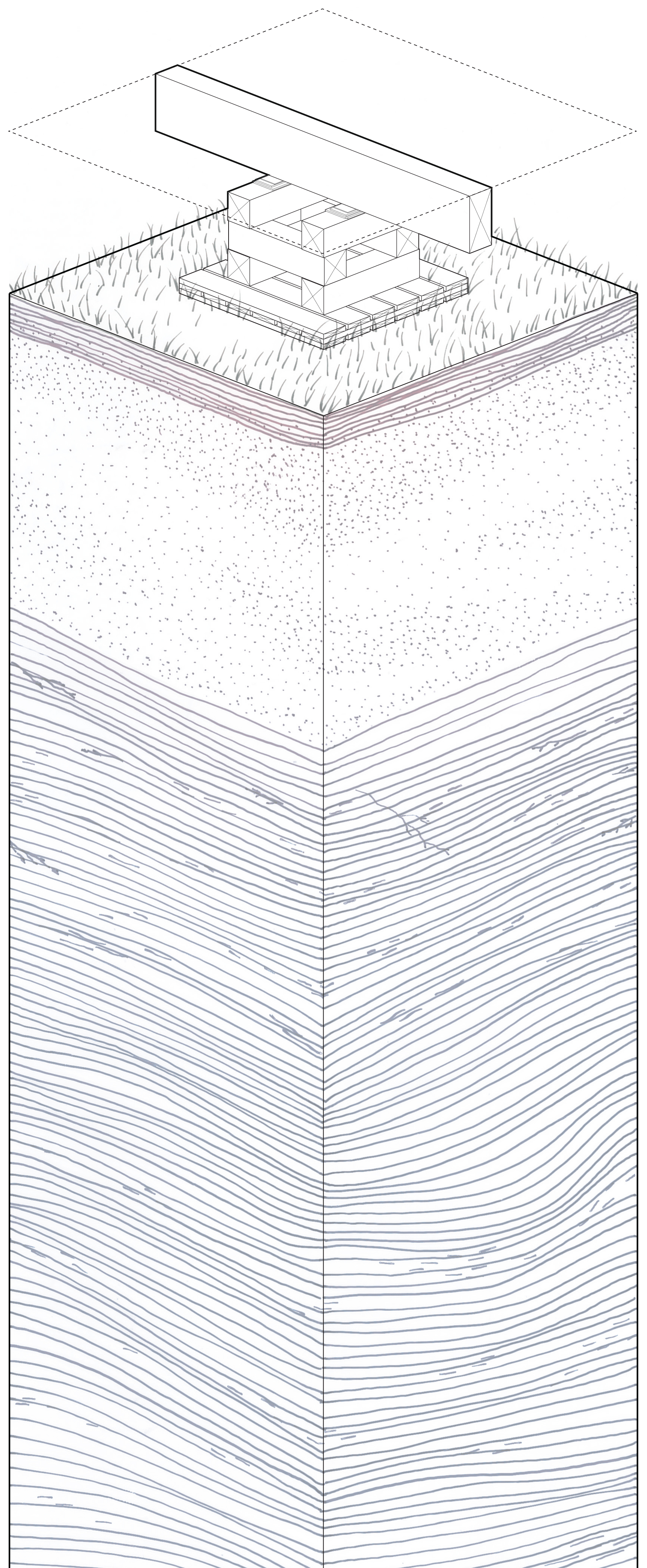
The typical timber surface foundations of Old Crow move with the land, embodying the environment’s constant modulation. As they shift to accommodate the heaving and settlement of the ground, they also move with the seasonal cycles that intermittently freeze and thaw the surface of the earth, or “active layer”. When the ground regains stasis after its spring melt and summer settlement, these foundations are re-leveled. Gravel pads are flattened and timber blocks that have been altered in an exchange between the site’s settlement and the building’s physical presence are shimmed; in the process, the building creaks and groans, telling its own narrative of change.
In Old Crow, as I reoriented myself with the bearings provided to me through conversations, I began to consider the foundation as a site of dialogue between building and land. The physical site of these foundations provided the space to ground open conversations and develop relationships with the people that built them. One of my most meaningful friendships was with respected Gwich’in Elder Stephen Frost, who spent much of his life living “out on the land.” Now in his eighties, he continues to return. It was because of Stephen’s generosity that I was able to visit the camp that he, like many local residents, had built along the Ch’oodèenjik (trans. Porcupine River).
We began our journey to Bluefish Camp by pushing the boat off of Old Crow’s gravel beach, its shallow aluminium hull scraping over rocks exposed by the falling river. The silty water embraced its metal frame, making velvety sounds beneath the water’s surface. Navigating towards the Alaskan border downriver, we passed bush camps seated atop steep and eroded banks, reminders of the continuous and contemporary relationships Vuntut Gwitchin citizens have with the land. After rounding another serpentine bend in the river, Stephen Frost’s family’s Bluefish Camp came into view: a collection of timber-frame structures along the river.
Earth rained down from beneath the steep bank’s undercut edge as we climbed a wooden ladder to the camp. From where we climbed, a small structure seated on the edge appeared to be moving in a slow descent towards the water. Its vertical log base sat on the shifting ground where the permafrost had already melted, and looked as if it would need to be moved before the bank’s impending collapse. This is not unusual: years ago, this eroded riverbank had collapsed below Bluefish Camp’s first cabin, sending both the building and the ground it was founded upon into the water.
Adapting to the changing landscape, Stephen built the Camp’s second cabin on firm, dry ground after the collapse of his first, locating it further away from the disintegrating shoreline. Unlike the raised cabins in Old Crow, this one rests directly upon the surface of the land, its log floor embracing the soil. Stephen had carefully selected the timber for its construction from his years of experience, choosing a stand of spruce trees just a few hundred feet behind the camp as the material, felling the logs in the spring when their sap began to flow. (11)
Many of the other buildings at Bluefish Camp are also founded on the surface of the ground. The smokehouse, an open outdoor structure for curing meat, has an earthen floor while its structure is literally rooted in place, anchored to the ground plane through the trunk of a limbed tree. Here, the figure-figure relationship between these timber structures and the soil beneath them is virtually unmediated.
This series of building foundation portraits suggest that in order to build upon the land, its dynamic nature, as experienced on site, must be considered. This requires a perceptual shift away from the seemingly widespread notion of the Canadian North as an “ice desert” or static field – dissonant Western projections that echo early European representations of the Arctic.
In Gerhard Mercator’s 1595 speculative polar map, the European cartographer constructed a drawing that fixed land in place, translating places both known and unknown onto meridians and parallels. At the centre of this projection sits the North Pole, fantastically depicted as an unmoving magnetic mountain: a “figure” located in space and projected against the static “ground”. (12) And yet, the land presents a different reality when magnetic declination turns compass needles away from True North. Here, the dip pole is engaged in a constant wandering, endlessly shifting the magnetic field. (13) If this is a region in constant geographical flux, how can it remain fixed in the South’s perception of it?
Much like the ephemeral phenomenon of magnetic north, the shifting nature of this land becomes evident as one approaches it. (14) These portraits of Old Crow might be considered a collection of dialogues. Each building foundation is the site of negotiation between the ground plane, people and a structure, entangled with dynamic environmental shifts. At the same time, each foundation has represented an important site for discussion between myself, in my attempts to be both an architectural student and attentive listener, and the minds and hands that built (and continue to rebuild) these structures. I am grateful to Stephen and the many other people who have generously taken me out on the land and shared their experiences of building upon it – experiences that are grounded in a deep knowledge of place.
During my relatively short time spent in this community, my own perspective of this place was in continual shift, oscillating between my complete disorientation as an outsider, and the knowledge I gained by spending time on the land and conversing with people who have a deep connection with it. While I have tried to render each portrait as honestly as possible, erecting each one on foundations of listening, conversing, and experiencing, there is no diagram or single story that can define a place or the people connected to it. I can only reflect on these narratives from my singular and shifting perspective, and point to the attuned knowledge held by those who live and build on this land that no newcomer’s understanding can ever approach. For locals, this place continues to shift as well – but they engage with these shifts day-to-day. Here, where a magnetic declination exists between the prescribed north of the map, and the experienced north of the compass, one can never consider this, or any other site, as a static and empty field. This is not a ground awaiting a figure.
Perhaps the outsider cannot determine how a building should touch the land.
Endnotes
I would like to thank the Vuntut Gwitchin First Nation for welcoming me onto their lands and Traditional Territory. I am deeply appreciative of the many community members that I had meaningful conversations with and those who took me out on the land. I am also grateful to the VGFN Heritage Branch for providing their feedback on this piece.
(1) Landscape historian Alessandra Ponte describes the perception of the Canadian North as a romantic and inaccessible place, or the “ice desert” that exists within the collective imagination of the South. See Alessandra Ponte, "Journey to the North of Quebec: Understanding (McLuhan's) Media," in The House of Light and Entropy (London: Architectural Association, 2013): 136.
(2) "Impacts of Climate Change," Government of Canada, accessed July 02, 2016, http://climatechange.gc.ca/default.asp?lang=En&n=036D9756-1.
(3) Dr. David Fortin (Assistant Professor of Architecture at Laurentian University and Métis scholar), discussion with the author, December 2016.
(4) Vuntut Gwitchin First Nation and Shirleen Smith, People of the Lakes: Stories of our Van Tat Gwich'in Elders, 1st ed. (Edmonton: University of Alberta Press, 2009): XXVI-XLI.
(5) J. Brown, O.J. Ferrians, Jr., J.A. Heginbottom, and E.S. Melnikov. 1998, revised February 2001. Circum-arctic map of permafrost and ground ice conditions. Boulder, CO: National Snow and Ice Data Center. Digital media.
(6) To expand, members of the self-governing Vuntut Gwitchin First Nation continue to be vital in protecting critical habitat areas of many animals threatened by oil and gas development in northern Yukon and Alaska including the Porcupine caribou herd.
(7) Brent B. Wolfe et al., "Environmental Change and Traditional use of the Old Crow Flats in Northern Canada: An IPY Opportunity to Meet the Challenges of the New Northern Research Paradigm," Arctic 64, no. 1 (2011): 130.
(8) Susan Schuppli, "Can the Sun Lie?" in Forensis : The Architecture of Public Truth, ed. Forensic Architecture (Berlin: Sternberg Press, 2014): 59.
(9) For a thorough discussion that unpacks the social and architectural impacts of the language of specifications often relegated to the technical see: Lloyd Thomas, Katie. “‘Of Their Several Kinds’: Forms of Clause in the Architectural Specification.” Arq 16, no. 3 (2012): 1–9.
(10) Dr. David Fortin (Assistant Professor of Architecture at Laurentian University and Métis scholar), discussion with the author, December 2016.
(11) Stephen Frost (Gwich’in Elder), discussion with the author, July 2016.
(12) Mercator, Gerardus. Septentrionalium terrarum descriptio. Per Gerardium Mercatorem cum privilegio. Map. 1595. From Library and Archives Canada, Mikan no. 3682241. http://data2.archives.ca/e/e177/e004414662-v6.jpg (accessed 5 January 5, 2016).
(13) The most recent official magnetic survey determined that the North Magnetic Pole is wandering and moving approximately north-northwest at 55km per year. See "Wandering of the Geomagnetic Poles," National Oceanic and Atmospheric Administration, accessed 18 January 2016, http://www.ngdc.noaa.gov/geomag/GeomagneticPoles.shtml.
(14) For an excellent survey of both fantastical and utilitarian work surrounding the phenomenon of magnetic north, see: Stankievech, Charles. Magnetic Norths : A Constellation of Concepts to Navigate the Exhibition. Montréal, QC: Galerie Leonard Bina Ellen Art Gallery, 2010.
Image Sources
Image 3 source: Image by author. Not technically accurate. Data sourced from: Canada Mortgage and Housing Corporation, “Residential Foundation Systems for Permafrost Regions,” March 2000.
Image 4 source: Image by author. Not technically accurate. Data sourced from: Canada Mortgage and Housing Corporation, “Residential Foundation Systems for Permafrost Regions,” March 2000.
Image 7 source: Mercator, Gerardus. Septentrionalium terrarum descriptio. Per Gerardium Mercatorem cum privilegio. Map. 1595. From Library and Archives Canada, Mikan no. 3682241. http://data2.archives.ca/e/e177/e004414662-v6.jpg (accessed 5 January 5, 2016).
Image 8 source: Image by author. Data sourced from: Chulliat, A., S. Macmillan, P. Alken, C. Beggan, M. Nair, B. Hamilton, A. Woods, V. Ridley, S. Maus and A. Thomson, 2014. The US/UK World Magnetic Model for 2015-2020. Boulder, CO: NOAA National Geophysical Data Center. doi: 10.7289/V5TH8JNW.
Kat Kovalcik is a designer based in Whitehorse, Yukon and Toronto, Ontario. Her M.Arch thesis groundwork has led her to the Arctic community of Old Crow, Yukon. Kat’s research interests include the intersection of material flows and environmental change in design, and their entanglement with spatial perceptions.


