This Ain't Toronto

// HOW SECURITY REORGANIZED THE SPACE OF THE CITY DURING THE 2010 G20 SUMMIT
By Kathryn Schwartzkopf
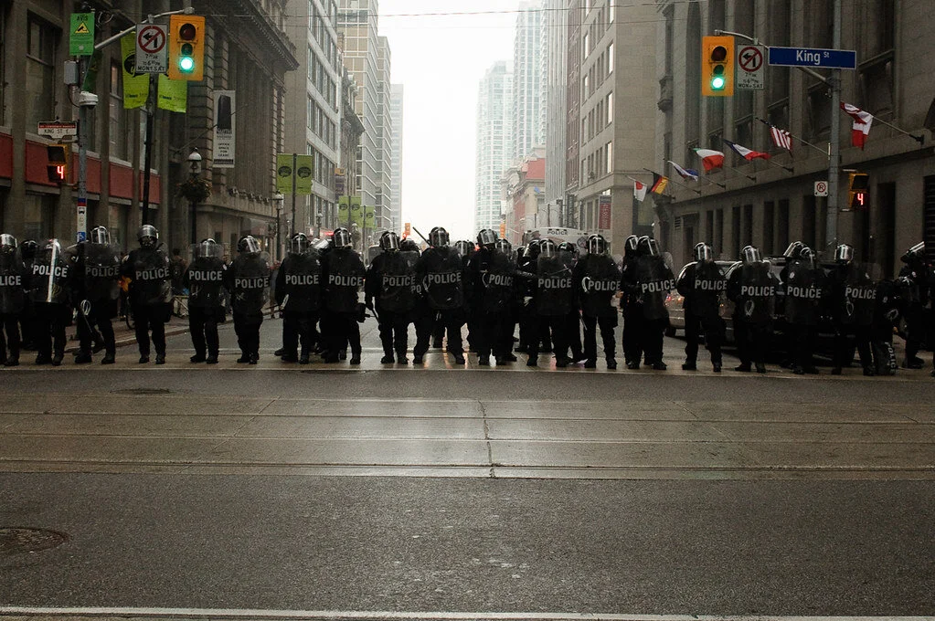
Image 1 | Riot police form a wall across Yonge St., preventing crowds from moving south towards the fence. Photograph by Kevin Konnyu
THE FENCE
By June 21, 2010, a 6 km fence built exclusively for the G20 Leader’s Summit made an island in the heart of downtown Toronto. The summit itself commenced five days later on June 26, 2010. With a 3 m high fence made of concrete jersey barriers and three different types of steel fencing, the “security zone” removed roughly six city blocks from the urban grid. The area inside was not open space. It carved a piece out of Toronto’s financial district, encompassed the iconic CN Tower, and encroached on Union Station and the Gardiner Expressway, two of the most significant transportation infrastructures in the downtown. The fence remained in place until the close of the summit on June 27, 2010. The Integrated Security Unit (ISU)—the temporary organization created to manage the security efforts—assured the public that hosting the summit at the Metro Toronto Convention Centre (MTCC) minimized the area of the security zone, and thus its impact on Toronto.
Even if this were the case, the G20 Summit security stretched well beyond the perimeter of the fence. The G20 leaders and dignitaries (Internationally Important Persons, or IPPs) rarely came into contact with the urban grid, but the effects of the increased security were felt throughout the city’s downtown. The fence detached the buildings, streets, and open spaces the G20 leaders occupied from the public space of Toronto. On arriving at Pearson International Airport, the majority of IPPs travelled via motorcade. Sections of highway were restricted as the motorcades passed, and the Bay/York St. exit of the Gardiner Expressway was closed for the sole use of the G20. Other IPPs travelled by helicopter into the security zone, landing on an open space at the base of the CN Tower, and never touching the grid at all. The ISU redesigned the area “inside” the fence to provide a highly controlled, and therefore safe, environment. The area of the security zone stretched to include every amenity the leaders needed, so they did not have to venture outside.
The G20 fence limited movement across the sequestered territory. Gates provided checkpoints to control the flow of people in and out of the area, and accreditation controlled who could gain admittance. Prior to the summit the ISU had to accredit approximately 40,000 people, mainly those who lived or worked inside the fence. Thus, with an unsympathetic steel fence and an army of police officers, the G20 interacted with the city of Toronto.
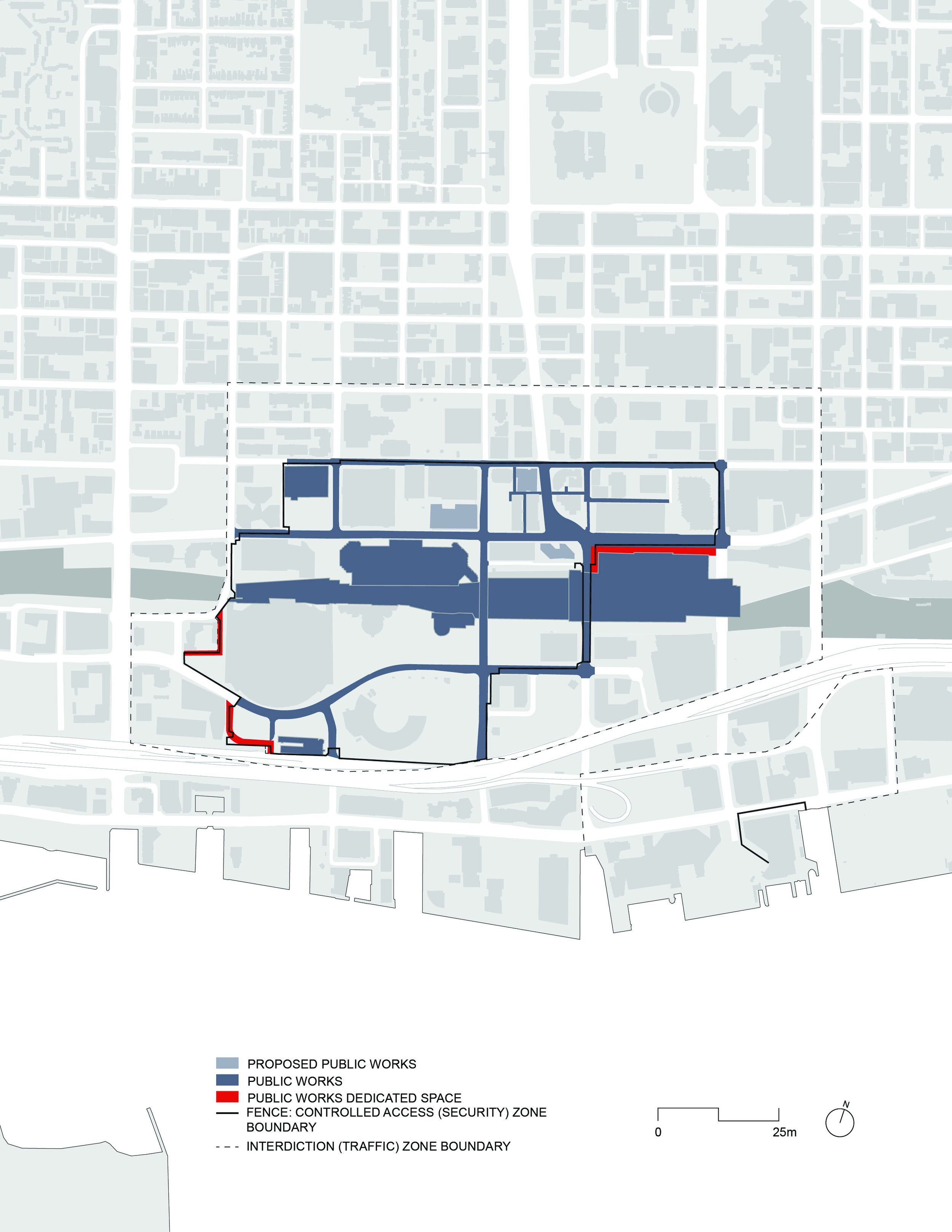
Image 2 | Public Works Protection Act Amendment
THE PUBLIC WORKS PROTECTION ACT
If the fence created the spatial condition of an island in the city, the Public Works Protection Act (PWPA) legally cemented it as an enclave. The PWPA is a World War II-era wartime measure to protect public works from attack. It gives peace officers the power to demand identification, search, and deny access to anyone wishing to enter a public work, which includes, “any railway, canal, highway, bridge, power works,” and “any provincial and any municipal public building.” [1] Currently, authorities still use this act to protect courthouses and government buildings in Ontario. During May and early June of 2010, the Ontario Provincial Government added an amendment to the Act.[2] The amendment defined the fence as a public work along with the streets, sidewalks, buildings, and ambiguous patches of ground within it (See Image 1). This gave the police the legal authority to identify, question and search anyone wishing to enter the security zone. The amendment was kept secret from the public. The government purposefully held back its passing until the last minute, and it was not publicly announced until the first arrest on June 24 brought it to everyone’s attention. [3]
Public misinformation empowered the police to search people outside of the fence. Searches targeted anyone approaching or walking along the fence, especially those taking photographs. Officers cited the previously unheard of “five-meter rule,” asserting that the PWPA empowered the police with search powers within 5 m of the fence. When one individual elected to move outside of the 5 m rather than submit to a search, one officer was recorded saying that it didn’t matter if they moved because they would still be on the street, a public work. The police were not particular about limiting searches to the 5 m and searched people throughout the downtown (See Image 3). Individuals who questioned the violation of their rights to be in public space and to maintain freedom from searches were either bullied into submission or arrested.
Anyone out in public space during the G20 Summit was faced with the uncanny experience of authoritarian control in a democratic society. As two officers bluntly stated, “This ain’t Canada anymore.” and “This is G20 land.” [4]

Image 3 | Search and Arrest
THE G20
The G20 is a supra- national governing body facilitating policy coordination between the nineteen member countries, the European Union (See Image 5), the World Bank and the International Monetary fund. While the G20’s scope of work extends to development, social equity, and climate change, its main agenda is the discussion of economic and financial issues. Excluded countries, as well as many concerned citizens of the G20 countries themselves, dispute the legitimacy of the G20 because its members are self-appointed. While the G20 asserts that it jointly controls 80% of the global gross domestic product, 80% of world trade, and makes up two-thirds of the world’s population, this neglects roughly 168 countries accounting for approximately 2.5 billion people, preventing them from influencing global initiatives.
The G20 Leaders’ Summits attract massive protests. Protest tactics are diverse, and international summits, in particular, attract violent demonstrations that are met by the equally violent force of riot police. Images of riot police, broken glass and burning police cars overshadow the signs and messages of the demonstrators. The extreme security measures taken in preparation to host the world leaders appear to be justified, if not because of the perceived threat of terrorist attack, then because of the vandalism and chaos caused by violent protest tactics.

Image 4 | The “controlled access zone” fence demarcates the border between the public space of Toronto and the G20’s security zone. Defence-in-depth is illustrated by the lines of police along the fence and the sparsely populated interdiction zone immediately outside of it. Photograph by Andrei Arkhanguelski

Image 5 | G20 Nations
HEIRARCHY OF ZONES
The fence was not simply a line between the world leaders and the rest of the city; it was a single element in a vast security apparatus. The security design re-conceptualized Toronto as a hierarchy of zones. Inside the fence, the security zone contained a hierarchy of three zones; a fence surrounded each zone (See Image 6). The first fence was a 3 m high, 1” chain link fence supported by a foundation of concrete jersey barriers. It surrounded the “controlled access zone.” This was the fence that represented the separation between the G20 and the public.
The ISU limited access inside the fence to people with legitimate purposes, such as work or residence. The second fence was a 3 m high, virtually seamless wall of 1⁄4” expanded metal. Concrete jersey barriers supported the fence from the inside. It surrounded the “restricted access zone.” The ISU restricted access inside the fence to people involved with the G20 Summit. The third fence was similar to the second fence except it used 2’ x 2’ x 4’ solid concrete blocks as ballast weights instead of jersey barriers and steel bracing between the fence post and ballast weight. It surrounded the “exclusive access zone” or the summit venue. The ISU restricted access inside the fence to people attending the G20 Summit.
The “controlled access zone,” the “restricted access zone,” and the “exclusive access zone” were reminiscent of spatial relationships of the walled city, the citadel, and the keep, building typologies from the Middle Ages. The walled city protected citizens from outsiders, the citadel was the defensive core of the city and the keep was the refuge of last resort. Similarly, the level of security and restriction to access of the G20 security zones increased as one approached the Metro Convention Centre. Even if aggressive protesters executed a successful attack on the fence, the police could fall back and regroup around the next fence and continue to defend the summit.
This strategy is known as defence-in-depth. It combines a network of security measures to overcome the brittleness of a linear defence. It can provide time and space to the defender once under attack. Eyal Weizman states:
…the spatial-organizational model of the network creates a more diffused and dynamic geography. Following this logic, the system of defense in depth has the capacity to exchange space and time alternatively. At the beginning of an attack it trades space for time—the attacker is allowed to gain space while the defender gains organization time. [5]
The G20 security design did not take any chances. Characteristically, defence-in-depth is over-engineered. The first lines of defence were drawn well beyond the fence and the security zone, embodied in by the legions of police manning the streets of Toronto.
The defence-in-depth security enveloped a larger area of Toronto than the public realized. According to the security plan, published before the summit, there were two clearly-defined zones: the “security zone” and the “traffic zone.” Actually, there were five distinct zones; the aforementioned MTCC, the “controlled access zone” and the “restricted zone” within the “security zone” and the “interdiction zone” and the “outer zone” (See Image 7). The “interdiction zone” was the traffic zone by a different name. This area was immediately beyond the fence.
It was open to the public but the ISU warned that there would be checkpoints and traffic delays. Police searches of people in the vicinity of the fence began as early as Monday, June 21. But searches extended far beyond the interdiction zone into areas of the city that people did not expect to come into contact with G20 security. The ISU did not inform the public about the “outer zone” prior to the summit. There was no perceptible demarcation of this zone. It extended north to Bloor, south to Lake Ontario, west to Dufferin Street, and east to Jarvis Street. The outer zone stretched to contain significant protester gathering places including Queen’s Park. Within the outer zone there was “increased vigilance” by the police. [6] While citizens of Toronto were not expecting to feel the security of the summit so far from the announced security zone, people soon discovered that identification and search were not limited to the region immediately surrounding the fence.

Image 6 | The Fence
THE FLATTENING OF VERTICAL SPACE
The US military predicts that, with rising urban populations, future wars will be fought in cities. [7] The military has enlisted architects and urban planners to develop their strategies for urban warfare. Their Doctrine for Joint Urban Operations sees the “urban terrain” as a multi-dimensional composition of surfaces and spaces categorized into airspace, surface, supersurface (above grade structures) and subsurface (below grade structures). The interiors of supersurfaces and subsurfaces are difficult for the military to surveil and manoeuvre through. [8] This complicates security because these spaces are difficult to control.
The ISU used similar spatial concepts to secure the downtown of Toronto. They secured the air space and subterranean infrastructure by means of restricted areas and surveillance. A no fly zone extended 30 nautical miles from the Metro Toronto Convention Centre (See Image 8).[9] The only non-police or military aircraft allowed to fly were commercial airlines, since airport security already identifies and searches people prior to boarding the plane. On Friday, June 25, the PATH, a secondary level of pedestrian circulation underneath the downtown, was put into lock down with 50 police guarding the area directly below the line of the fence. Limiting the paths of movement through the city pushed everyone onto the streets, inhibiting the vertical access of movement through the city and reducing the city to a two-dimensional plane where police could more easily control movement and surveil the crowd.

Image 7 | Security Zones
NO MAN’S LAND
Further limitations were placed upon the public space of Toronto when the area surrounding the fence was sterilized and stripped down to its bare minimum. The police removed street amenities and art; elements considered essential to the shaping and use of public space were now regarded as potential weapons. This included the removal of garbage cans, bicycle racks, and street furniture; even trees were uprooted. The public witnessed these erasures as far as University Avenue, where police removed stone trim from the central boulevard planters. Elements that could not be removed, such as monuments and fountains, were covered in plywood. The security further reduced life in the public spaces of the downtown by influencing closures of businesses, banks, tourist attractions, and restaurants.
The proximity of the security zone to Union Station affected public transit in and out of downtown Toronto. Every day, approximately 200,000 people pass through Union Station. During the G20 Summit, Via Rail suspended service to Union Station, forcing people travelling to Toronto to disembark at suburban stations and transfer to a bus to shuttle them downtown. On June 26, the police encouraged people to remain out of the downtown because of the traffic delays. TTC subway service was suspended south of Bloor, and Go Transit stopped service to Union Station once the protests were underway. Services did not resume until 10:00 a.m. the next morning. The PATH was locked down because of its access into the security zone. The restrictions were successful in frustrating movement and accessibility throughout the downtown. The police regarded the people who remained in public space with suspicion. Social media and news reports described the city as a ghost town.

Image 8 | No Fly Zones
SPACE AND POWER
One thousand, one hundred and eighteen (1,118) people were arrested over the course of the G20 Summit, the largest mass arrest in Canadian history. Many people unfamiliar with the heightened level of policing associated with international summits, acting as they would have under normal conditions, joined the long list of the arrested. As soon as the fence was constructed and the security apparatus supporting it set in place, Toronto became two cities: the everyday Toronto, and G20 land.
Spatial organization is a mirror image of socio-political organization: it mediates social relations. As the physical manifestation of spatial organization, architecture can be an instrument of power. Anselm Franke states:
Space is a fundamental category for any form of power. It is a medium of social relations, articulated as physical and symbolic distance, proximity, position, opposition, and simultaneity. The production and control of space is thus crucial to any execution of power, representing its potency, reproducing social order, and neutralizing and naturalizing its objectives through planning processes that lead to a specific physical layout. Any claim to power and property manifests and institutionalizes itself in the act of territorialization.[11]
There is a direct relationship between the organization of terrain and the ability to control it.
Density, congestion, and diversity are characteristics of any city that can incite unpredictable situations, which conflict with security’s goal to maintain a safe environment. The ISU reshaped the space of downtown Toronto to serve the interests of the authorities; mainly, the absolute security for the G20 Summit. To neutralize the city’s potential for instability, the security apparatus changed the spatial relationships and flows of Toronto by creating an enclave, redefining the horizontal space into a hierarchy of zones, flattening the vertical space of the city, increasing surveillance and creating a no man’s land in the heart of downtown Toronto.
Part of the power of the event was its temporary nature, which served to justify the transformations that it imposed on the city. There are no physical ruins left behind to signify the spatial relationships the G20 layered on the city of Toronto. Nonetheless, there is a danger that methods of control that exploit the architecture of the city will persist through the form of the city, even after the initial intention for the design no longer exists. The ISU brought police from all over the country to be trained in crowd control.[12] These police take their knowledge and experience back to their respective communities. The RCMP has also created a database to preserve the framework for the security apparatus so that it can be applied to future events. [13] In all likelihood, a similar reconfiguration of downtown Toronto or other Canadian metropolitan centres will happen again.

Image 9 | CCTV Cameras
Endnotes
[1] Gerry McNeilly, “Policing the Right to Protest: G20 Systemic Review Report” Office of the Independent Police Review Director (Toronto: Queen’s Printer for Ontario, 2012), 73, http://www.oiprd.on.ca/EN/PDFs/G20-Systemic- Review-2012_E.pdf.
[2] André Marin, “Caught in the Act: Investigation into The Ministry of Community Safety and Correctional Services’ conduct in relation to Ontario Regulation 233/10 under the Public Works Protection Act,” Ombudsman Ontario. (December 2010), 15, http://www.ombudsman. on.ca/Ombudsman/files/58/581252d9-1809- 4291-831b-88e9adb480c5.pdf.
[3] Jennifer Yang, “Just being near the G20 security zone can get you arrested,” Toronto Star (Toronto, ON), June 25, 2010, http://www.thestar.com/news/gta/g20/2010/06/25/ just_being_near_the_g20_security_zone_can_get_you_arrested.html.
[4] mikesmusings, “This isn't Canada anymore,” YouTube video, 4:23. September 13, 2010. https://www.youtube.com/watch?v=E7tE-BArgHM.
[5] Eyal Weizman, Hollow Land: Israel’s Architecture of Occupation (New York:Verso, 2007), 67.
[6] Toronto Police Service, “G20 Summit, Toronto, Ontario, June 2010: Toronto Police Service After-Action Review,” (2011), 8, http://www.torontopolice.on.ca/publications/files/reports/ g20_after_action_review.pdf.
[7] The Joint Chiefs of Staff, “Joint Urban Operations”, Joint Publication 3-06, (November 20, 2013): I-1, http://www.dtic.mil/doctrine/new_pubs/jp3_06.pdf.
[8] Joint Chiefs of Staff, “Joint Urban Operations”, Joint Publication 3-06, (November 20, 2013): II-10 – II-11, http://www.dtic.mil/doctrine/new_pubs/jp3_06.pdf.
[9] Transport Canada, “G8 Summit Meeting Huntsville/Deerhurst Resort, Ontario 25 AND 26 June 2010, G20 Summit Meeting Toronto, Ontario 26 AND 27 June 2010, Class “F” Restricted Airspace,” AIP CANADA (ICAO) SUPPLEMENT 11/10, May 6, 2010, http:// www.navcanada.ca/ContentDefinitionFiles/Publications/AeronauticalInfoProducts/AIP/ Current/PDF/EN/part_4_AIP_sup/4aip_sup_eng.pdf (site discontinued).
[10] “Dozens of police face discipline over G20 ID badges,” CBC News. November 3, 2010, accessed March 26, 2011, http://www.cbc.ca/news/canada/toronto/dozens-of-police-face-discipline-over- g20-id- badges-1.877079.
[11] Anselm Franke, "Territories,” in Territories: Islands, Camps and Other States of Utopia, ed. Anselm Franke (Berlin: KW, Institute for Contemporary Art, 2003), 10.
[12] “Calgary police return from G20 duty,” CBC News. June 28, 2010, http://www.cbc.ca/ news/canada/calgary/calgary-police- return-from- g20-duty- 1.896612.
[13] Brian London, David Wrather and Peter Johnson, , “The Integrated Security Unit -After Action Review,” Royal Canadian Mounted Police After Action Report, (2011), 28, http:// www.documentcloud.org/documents/268236-00001- a0261311.html#document/p3.
Bio
Kathryn Schwartzkopf is an architectural designer based in Seattle. She has a Bachelor of Architectural Studies (2008) and a Master of Architecture (2015) from the University of Waterloo. Her research interests include the politics of public space, security design and forensic architecture.