A Discussion on Tech in Toronto // Design

A Discussion on Tech in Toronto - part ii | Design
//Sidewalk Labs' project to build the Quayside community "from the internet up"
By Aisling O’Carroll
NOTE: This is a multi-part series to be released online over the next few months. See the other parts here.
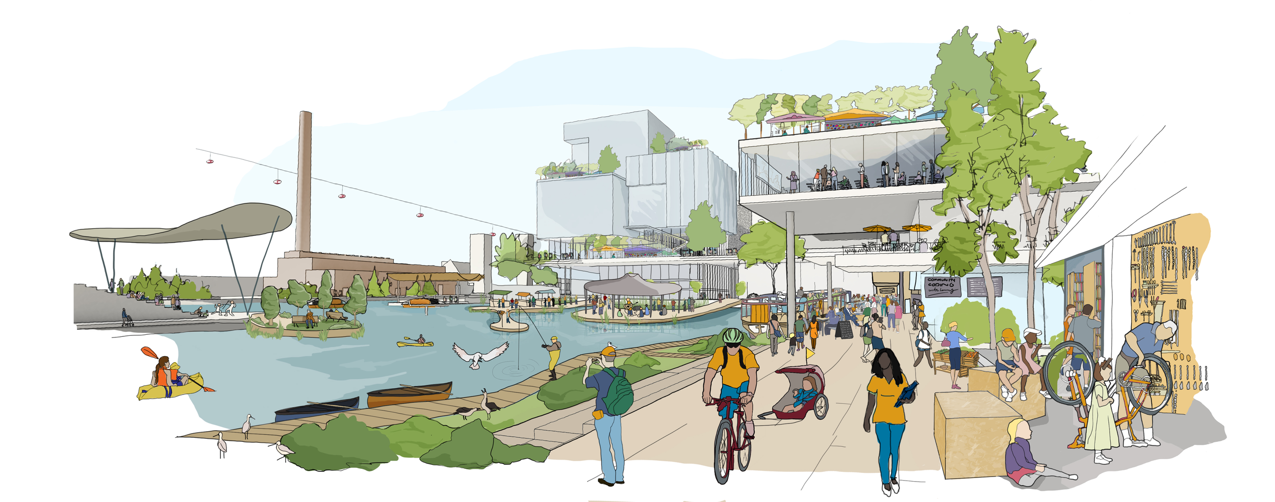
IMAGE ABOVE: Sidewalk Labs envisions a flexible urban fabric that can accommodate changing building and market needs and support mixed-use development.
Illustration by Sidewalk Toronto.
DESIGN
As director of Design at Waterfront Toronto, can you describe Waterfront Toronto’s ambition and vision for the Quayside community?
Pina Mallozzi (PM) | Waterfront Toronto’s long-term aspiration for Toronto’s waterfront is to create vibrant, connected, climate positive, resilient, and prosperous communities, and to date we have had a lot of success in accomplishing our mission. Quayside is the natural evolution of Waterfront Toronto’s mandate, and builds on what we have already been doing for more than fifteen years. Through this project we are striving to address some of the pressing challenges that growing urban centres around the world face today, such as inclusivity, accessibility, climate change, changing economy and job market, innovation, and productivity, while maintaining the high standard of design excellence that Waterfront Toronto is known for.
Waterfront Toronto’s board and staff are acutely aware of our responsibility to the public. Through this experimental partnership with Sidewalk Labs—and our collaboration with our stakeholders, government partners, and Toronto community members—we have a unique opportunity to establish Quayside as a globally significant mixed-use project that can be a benchmark for sustainable, inclusive, and accessible urban development.
What kind of technologies and smart systems can we expect to see in the Quayside community?
PM | We have been looking into several different digital technologies and innovations that could help make Quayside the global hub of urban innovation. From the mobility perspective, we are exploring different solutions to help build complete streets that centre on the wants and needs of the people using them.
We want Quayside to be seamlessly connected to the City of Toronto through the extension of existing city infrastructure like light rail transit and road networks. We have also challenged ourselves to establish methods for prioritizing pedestrians in our streets. One way we’ve been looking to address this is through adaptive traffic lights, where the traffic light could detect the speed that pedestrians are crossing the street and adjust its timing accordingly. This technology is a game-changer in making pedestrians feel safe on busy city streets while also preserving accessibility and mobility in a shared space. Other technologies we’re looking into are designs where people can use their phones to check if a public space is available for permit and book it for a specific time. For example, if a person wanted to book a larger space within the public realm for a pop-up shop, they could do so instantly. These are just a few examples of systems we could develop for the area. Right now, we are engaged in an extended consultation and planning process to shape the Master Innovation and Development Plan (MIDP), so there have been no final decisions made on which technologies we want to move forward with for Quayside, but we are excited about the possibilities that technology can bring to conventional practices.
What are the advantages and opportunities of integrating technology with architecture, infrastructure, and planning? What are the challenges and risks?
AnnaLisa Meyboom (AM) | We currently view technological advances relating to the city with a utopian optimism. Although the benefits to the citizen seem largely undefined at this point, there is nevertheless an assumed increase in efficiency and therefore somehow an added agency to the citizen that is expected to accrue. Technology, however, is neither good nor bad—it is how it is used that results in positive or negative outcomes. Take intelligent road pricing for example: a comprehensive smart system for monitoring car traffic, similar to simpler systems in London, Stockholm, or Milan, could track cars within any zone of the city and charge them according to time in specific zones, distances travelled, or as they pass any specific locations. To do this, we understand that the location of any particular vehicle would be known more or less at any given time. This could be viewed as a positive or negative development—on the positive side it is a proven tool for reducing car traffic in cities; on the more negative, it could result in a tax increase to citizens as well as several problems with privacy. (1) However, there are other potential issues which are maybe not so easily foreseen: what if a very expensive residential area decided they didn’t want too much traffic through their neighbourhood and they lobbied to put the price of travelling through a specific area so high that only an elite set of drivers could afford to access that area? Authors such as urban geographers Stephen Graham, Simon Marvin, and Erik Swyngedouw state that “road pricing or other linear methods of controlling or excluding particular social groups from getting control over space, equally limits the power of some while propelling others to the explosive heights of controlling space, and therefore everything contained in it.” (2) Other smart technologies can achieve the same purpose: bollards that disappear into the ground when vehicles with the correct RFID approach for example, similar to those already in use in downtown Amsterdam, will achieve the same end of limiting access to only a certain group of drivers. The question in the case of smart road pricing is whether or not this technology results in an erosion of the public nature of the street. This is just one example of a technology’s potentially negative effects from the positive intention behind its use.
Chris Green (CG) | One of the key opportunities for urban technologies is the possibility to change the way we program cities and define how spaces are used in a much more responsive fashion. Professionals of the built environment have typically been taught to think of spatial program volumetrically, as containers of activity, bound or defined by physical envelopes or thresholds, whether it’s the residential zoning of an urban plan or the entrance lobby of a building. However, this is an inherently static way of thinking about the urban environment and means we often make many assumptions about how spaces will be used, without a means to measure or adapt to change when these assumptions fail. Digital technology provides us with a way of designing a more adaptable urban realm, giving us a new arsenal of tools that enables us to identify and respond to human needs, and address them through the design of responsive products, services, and spaces, alongside traditional architecture and urban design. This means taking a more holistic and strategic approach to the design of the built environment that is driven by the user experience and avoiding the assumption that a building or urban plan is the sole answer.
One of the clear dangers is the high level of tech-opportunism today, with many ripe technologies still looking for a use case and countless technology vendors attempting to woo cities, developers, and institutions with slick demos and product specs. When urban design practices shift into this market structure, the design of our civic spaces and public experience runs the risk of following market-driven patterns and potentially eroding the democratic process behind these spaces.
Mariana Valverde (MV) | I don’t think there can be any general answer to this question. One can’t say anything useful about technology in general. We have to ask about specific technical choices, and ask not only how it works but where and how it is being used, who owns it, who controls or governs its use. For example, a so-called smart phone or a “smart” home security camera can be used by women to increase their own safety—but the same gadgets can also be used by abusive husbands to pester, control, and frighten women. All technology exists in a particular social, economic, and political context, and is used by certain groups for particular purposes.
What opportunities and/or risks do automated systems, like driverless cars or drones, offer in urban design and planning?
CG | Beyond operational efficiency, automated and autonomous systems could potentially have a powerful impact on the urban environment if we approach them in the right way. For example, what if we think of driverless cars not only as a solution to convenient urban mobility but as a means to reclaim the street and repurpose parking spaces for other uses? This would require a more strategic approach involving a series of parallel initiatives going beyond just the autonomous vehicle, from designing shared shuttle services to deploying alternative multi-modal transport options and ride-share infrastructure, as well as new environmental elements such as green infrastructure or street furniture. Seen together, we can use these interventions to transform the streetscape, from vehicle-centric arteries into places designed for people. What’s crucial is that we look to understand these knock-on benefits of the available technologies.
AM | The risk of an automated transport system in terms of urban design is that it further isolates people by having people picked up and dropped off at their home, further degrading public space and public interactions. Health outcomes are likely also an issue in this regard since people could potentially walk or bike less.
However, the development of robust automated mass transit with last-mile autonomous transportation would provide an alternate which would take advantage of the technology, reduce congestion, improve health outcomes, and still engage the public at “stations” or “hubs.” This approach also offers the opportunity to provide public spaces connecting automated mass transit to last mile autonomous vehicle solutions (shuttles for example) as well as bikes, small electric (bikes and kickboards), etc. Other aspects to mitigate the potential negatives include the design of public pick-up and drop-off zones as well as the rethinking of building or community mailboxes (or delivery boxes), front entries, and other more detailed building configuration issues. The point of these public infrastructures is both to ensure that all members of society can access transportation services whether or not they have a mobile phone (social equity), as well as to create engagement and interaction that may be lost as people become more isolated (social engagement).
previous: part i | Smart City
next: part iii | Tech(nologists) and Design
Endnotes
(1) Liesbet Van Zoonen, “Privacy Concerns in Smart Cities,” Government Information Quarterly 33, no. 3 (2016): 472–480. See discussion regarding areas of privacy concerns for citizens.
(2) Erik Swyngedouw, “Communications, mobility and the struggle for power over space” in Transport and Communications in the New Europe, eds. G. Giannopoulos and A Gillespie, (Belhaven: London, 1993), 305–325, quoted in Stephen Graham and Simon Marvin, Splintering Urbanism: Networked Infrastructures, Technological Mobilities and the Urban Condition (New York: Routledge, 2001), 251.